Search Term Record
Metadata
Name |
Sotoyome Soil Conservation District |
Related Records
-
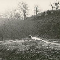
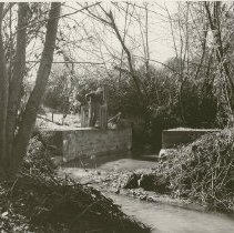
2007.01.092 - Print, Photographic
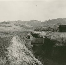
Outflow of new dam, no date Sotoyome Soil Conservation District, number on left edge of photo: C-1999-7
Record Type: Photo Archives
-
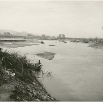
2007.01.093 - Print, Photographic
Russian River [?], no date Sotoyome Soil Conservation District, number on left edge of photo: C-2027-7
Record Type: Photo Archives
-
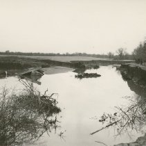
2007.01.094 - Print, Photographic
Russian River [?], no date Sotoyome Soil Conservation District, number on left edge of photo: C-2000-11
Record Type: Photo Archives
-
2007.01.095 - Print, Photographic
Group drainage, Healdsburg Slough, looking south , Butts Bridge, January 1957 Sotoyome Soil Conservation District, number on left edge of photo: C-2199-12
Record Type: Photo Archives

-
2007.01.096 - Print, Photographic
Group drainage, Healdsburg Slough, looking north, Kalke Ranch, January 1957 Sotoyome Soil Conservation District, number on left edge of photo: C-2199-11
Record Type: Photo Archives

-
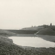
2007.01.097 - Print, Photographic
Johnson Dam, 18 ac. ft., 1956 Lytton Road; dam beginning to fill for first time Sotoyome Soil Conservation District, number on left edge of photo: C-2189-7
Record Type: Photo Archives
-
2007.01.098 - Print, Photographic
Salz Dam, 25 ac. ft., 1956 Lytton Springs Road (near west end); dam beginning to fill for first time Sotoyome Soil Conservation District, number on left edge of photo: C-2184-8
Record Type: Photo Archives

-
2007.01.099a - Print, Photographic
Drop structure (4 ft.). Above this structure are 9 2-ft drops and an 18 ac. ft. retention dam. Young ranch, Alexander Valley, constructed in 1956 Sotoyome Soil Conservation District, number on left edge of photo: C-2189-1 See also similar photo, 2007.01.099b, not scanned (C-2189-1 also)
Record Type: Photo Archives
-
2007.01.100 - Print, Photographic
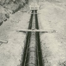
Pipeline in ground, no date Sotoyome Soil Conservation District, number on left edge of photo: C-2164-7
Record Type: Photo Archives
-
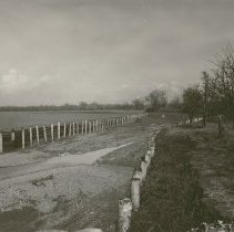
2007.01.101 - Print, Photographic
After Photo - 1956 flood. New bridge; in background are revetments on the Schwab and Lazzaroni Ranches, 1956 Sotoyome Soil Conservation District, number on left edge of photo: C-2189-12
Record Type: Photo Archives
-
2007.01.102 - Print, Photographic
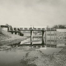
Sans flashboard Dam, constructed 1956, cost $5,250, no date Sotoyome Soil Conservation District, number on left edge of photo: C-2189-11 Possibly Felta Creek, see 2007.01.103
Record Type: Photo Archives
-
2007.01.103 - Print, Photographic
Flashboard Dam, Felta Creek, Art Folger Ranch, 1957 Sotoyome Soil Conservation District, number on left edge of photo: C-2199-6
Record Type: Photo Archives
-
2007.01.104 - Print, Photographic
Retaining wall along creek, no date Sotoyome Soil Conservation District, number on left edge of photo: C-2027-2
Record Type: Photo Archives
-
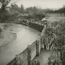
2007.01.105 - Print, Photographic
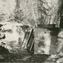
Wire and piling revetment, Demostene Ranch, constructed in 1956, Sausal Creek, no date Sotoyome Soil Conservation District, number on left edge of photo: C-2189-5
Record Type: Photo Archives
-
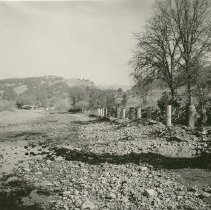
2007.01.106 - Print, Photographic
Plank and piling revetment on the Schwab and Lazzaroni Ranches, January 1957 An After photo (after 1956 flood) Sotoyome Soil Conservation District, number on left edge of photo: C-2199-10
Record Type: Photo Archives
-
2007.01.107 - Print, Photographic
Oats Cover Crop on Schwab Ranch, January 1957 Sotoyome Soil Conservation District, number on left edge of photo: C-2199-10
Record Type: Photo Archives
-
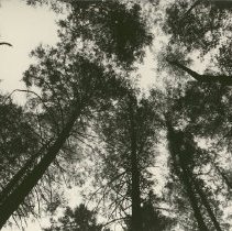
2007.01.108 - Print, Photographic
Looking up into canopy of fir trees, no date Sotoyome Soil Conservation District, number on left edge of photo: C-1919-11
Record Type: Photo Archives
-
2007.01.109 - Print, Photographic
Ninety year old stand of Douglas fir. This area was checked following the December 1955 floods and no erosion nor excessive runoff was noted. This is ideal cover. Returns from stumpage has averaged 11.55 per year based on an assumed price of $10.00 per thousand, no date Sotoyome Soil Conservation District, number on left edge of photo: C-1919-11
Record Type: Photo Archives
-
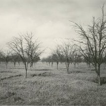
2007.01.110 - Print, Photographic
Douglas fir forest slash, no date Sotoyome Soil Conservation District
Record Type: Photo Archives

-
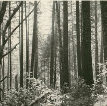
2007.01.111 - Print, Photographic
Douglas fir forest stumps, during process of lumbering, no date Sotoyome Soil Conservation District
Record Type: Photo Archives
