Search Term Record
Metadata
Name |
water supply |
Related Records
-
1026P - Print, Photographic
(Left to right) Charlie Hearing (smoking pipe), George Kelly, Orrin? (Garin?), Morgan, and Sam Hankins, Street Superintendent, repairing old water main leading from old well to pump located in Station, 1906 or 1907. Looking at south wall of present building.
Record Type: Photo Archives

-
2006.01.336 - Print, Photographic
Water to a Mountain, November 1966 Bring water to McDonough Heights Rd. off fitch Mtn. Rd. Fred Citti, George Gondola, Shorty Lownes (not identified by position)
Record Type: Photo Archives
-
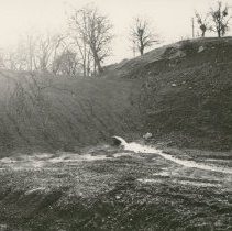
2007.01.092 - Print, Photographic
Outflow of new dam, no date Sotoyome Soil Conservation District, number on left edge of photo: C-1999-7
Record Type: Photo Archives
-
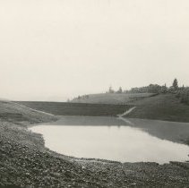
2007.01.097 - Print, Photographic
Johnson Dam, 18 ac. ft., 1956 Lytton Road; dam beginning to fill for first time Sotoyome Soil Conservation District, number on left edge of photo: C-2189-7
Record Type: Photo Archives
-
2007.01.098 - Print, Photographic
Salz Dam, 25 ac. ft., 1956 Lytton Springs Road (near west end); dam beginning to fill for first time Sotoyome Soil Conservation District, number on left edge of photo: C-2184-8
Record Type: Photo Archives

-
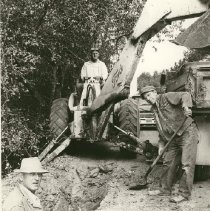
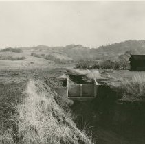
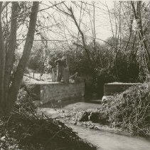
2007.01.099a - Print, Photographic
Drop structure (4 ft.). Above this structure are 9 2-ft drops and an 18 ac. ft. retention dam. Young ranch, Alexander Valley, constructed in 1956 Sotoyome Soil Conservation District, number on left edge of photo: C-2189-1 See also similar photo, 2007.01.099b, not scanned (C-2189-1 also)
Record Type: Photo Archives
-
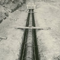
2007.01.100 - Print, Photographic
Pipeline in ground, no date Sotoyome Soil Conservation District, number on left edge of photo: C-2164-7
Record Type: Photo Archives
-
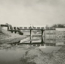
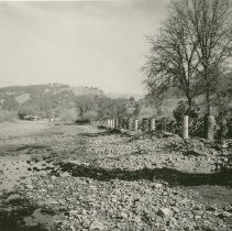
2007.01.101 - Print, Photographic
After Photo - 1956 flood. New bridge; in background are revetments on the Schwab and Lazzaroni Ranches, 1956 Sotoyome Soil Conservation District, number on left edge of photo: C-2189-12
Record Type: Photo Archives
-
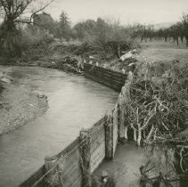
2007.01.102 - Print, Photographic
Sans flashboard Dam, constructed 1956, cost $5,250, no date Sotoyome Soil Conservation District, number on left edge of photo: C-2189-11 Possibly Felta Creek, see 2007.01.103
Record Type: Photo Archives
-
2007.01.103 - Print, Photographic
Flashboard Dam, Felta Creek, Art Folger Ranch, 1957 Sotoyome Soil Conservation District, number on left edge of photo: C-2199-6
Record Type: Photo Archives
-
2007.01.104 - Print, Photographic
Retaining wall along creek, no date Sotoyome Soil Conservation District, number on left edge of photo: C-2027-2
Record Type: Photo Archives
-
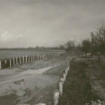
2007.01.105 - Print, Photographic
Wire and piling revetment, Demostene Ranch, constructed in 1956, Sausal Creek, no date Sotoyome Soil Conservation District, number on left edge of photo: C-2189-5
Record Type: Photo Archives
-
2007.01.106 - Print, Photographic
Plank and piling revetment on the Schwab and Lazzaroni Ranches, January 1957 An After photo (after 1956 flood) Sotoyome Soil Conservation District, number on left edge of photo: C-2199-10
Record Type: Photo Archives
-
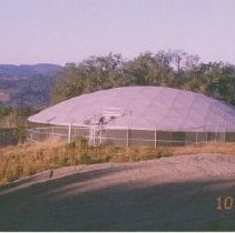
2010.18.009 - Print, Photographic
Healdsburg Reservoir, on fire road at end of Sunnyvale Avenue, 2002
Record Type: Photo Archives
-
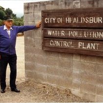
2011.01.007 - Print, Photographic
Bill Lucius at entrance to City of Healdsburg Water Pollution Control Plant, Dedicated, March 15, 1972
Record Type: Photo Archives
-
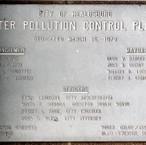
2011.01.008 - Print, Photographic
Metal Plaque at City of Healdsburg Water Pollution Control Plant, Dedicated, March 15, 1972
Record Type: Photo Archives
-
2053P - Print, Photographic
West St. (Healdsburg Avenue) across from the Plaza, January 1900 Digging trenches for water lines Handwritten on back: "Museum copy of 2053P"
Record Type: Photo Archives
-
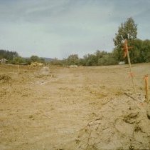
270-26 - Print, Photographic
Building Healdsburg City Holding Pond, No date Looking north between Healdsburg Avenue and Grove Street Note on back: #1
Record Type: Photo Archives
-
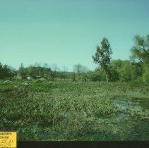
270-27 - Print, Photographic
Healdsburg City Holding Pond, No date Sticker on front: Plaintiff's Exhibit #11 EV ID 129473 Notes on back: "#2. Looking north between Healdsburg Avenue and Grove Street. See #1, same location"
Record Type: Photo Archives
-
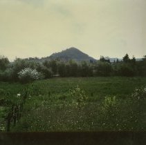
270-28 - Print, Photographic
As noted on the back: "Looking at Fitch Mt. from Grove St. Forground now is the city holding control pond. 1983."
Record Type: Photo Archives